 Greg and his Super Ximango
Abandoned railway bridge, near paisley
Neat small bridge, on a side road
At some point, I noticed that the old topographical maps of southern Ontario have a lot of railway lines marked in, while the road maps of Southern Ontario contain far fewer railway lines. I figured these former railway lines might be worth exploring.
Of course, there are a lot of railway lines that used to be, and most of the former lines are not actually all that interesting. The best way to do it, I figured, was to have a look from the air first. This is where its handy to know somebody with an airplane!
Greg and his Super Ximango
Using GPS utility, and some stitched together maps, I created tracks for all the abandoned railway lines between waterloo and Owen Sound. I uploaded these onto my GPS. My GPS isn't a mapping GPS, and even if it was, I probably wouldn't be able to create maps for it anyways. But it does show track logs, so I just made 'tracks' for all the railway lines.
On taking the flight, the most interesting stuff was all near a little town called Paisley, not far from Port Elgin, Ontario. Below is a topographical map. For the victoria day weekend, 2003, my brother Markus and I drove up that way to check out some of the sights from the ground. The pages linked from this page are of the photos we took of what we found.
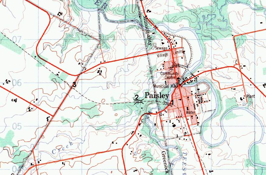
The bridge marked with the '1' is a partially wooden trestle. The road goes under one side of it, so very easy to get at, at least from that side.
The bridge marked with the '2' is very hidden away, not visible from any road. We ended up parking the car at the spot marked '3', and walked to it. Note that the normal topographical maps don't even have this bridge marked in. The marking for that bridge is my addition.
In addition, a few kilometers from there, is Neat little bridge going over side road 28/29, between Port Elgin and Paisley.
If you go, and have a GPS receiver, the waypoints on the map are:
1: N44.302772 W081.277253
2: N44.303083 W081.284820
3: N44.305922 W081.303974
And the small bridge, not on the map, is at:
N44.343602 W081.343990
Also check out my Ruins page
![]()